During a recent vacation, I visited the four (water-)falls
trail and the Sgwd yr Eira (Waterfall of the snow). The
Sgwd yr Eira is probably the most famous waterfall in South
Wales, because it is possible to walk behind it. The reason
for this blog post is mostly that before going there,
I tried to google the trail and the waterfall, and I came
up almost blank. Although there are of course some pictures
of the fall and a few descriptions of the walk, I found
all of them very confusing and sort of missing the big
picture. With this post I will try to clear up some of
the confusion. Note however that I do not have detailed
knowledge of the area, I'm writing from my limited
experience.
So for starters I made a map. The following
map is a openstreetmap.org
Export with some additional information added:
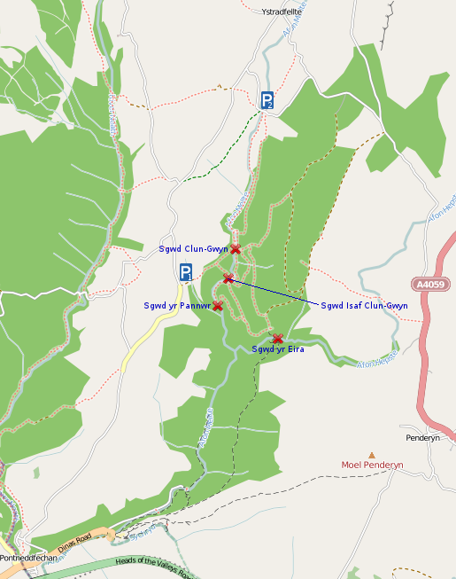
And here are some (hopefully) helpful bits of information:
- The four waterfalls trail (or just "four falls trail"),
as the name suggests, visits four waterfalls along its way (marked
with an X on the map), with the most famous one being the
Sgwd yr Eira.
- The walk is located in a triangle between the
villages of Pontneddfechan, Penderyn and Ystradfellte in
the Brecon Beacons National Park.
- It will take a few hours to do the walk, in our case almost
6 hours, but we had a few disctractions on the way. A realistic
time estimate would be 4 hours without detours.
- You will need proper hiking shoes, as parts of the walk
are muddy, going through small ditches, over uneven stony
surfaces and roots, or just slippery as hell. I hear
there are a few casualties every year, and I'm not
surprised.
- Your first stop in any case should be the Waterfalls
centre in Pontneddfechan. There you can buy a map set
for (at the time of writing this) 3 Pounds. It contains
the Four Falls Trail as Route number 7. Get it, I
mean it. All maps of this area I found online are
somewhere between incomplete and completely wrong. That
even applies to Openstreetmap, which lists some nonexistant
ways but misses some important others (unfortunately, I
did not have enough GPS data from my walk to correct
this). There are also numbered signposts along the
way, that are marked on the maps in the mapset, which
is very helpful. It's money well spent.
- Forget cellphone reception, there is none. You'll
probably have to walk for a while to even get an emergency
call out. Random trivia: Nedd valley, the last place
to get connected to the electricity grid on the
British main land in 2005 (!), is only a few miles
away from there...
- You have a few options to get to the trail.
The two main ones
are the parking areas marked as P1 and P2 on the map.
P1 is really just a designated unpaved space on the
side of the road, and it's rather small. But if you start
there, you're only ten minutes away from seing the
first waterfall. P2 on the other hand is a pay and
display car park. It is properly paved and there are
toilets and a bench for a picnic. This car park is
also used a lot by cavers exploring the nearby caves.
There also might be two other options, but I did not
try these: There seems to be a way from
Pontneddfechan to Penderyn that passes the Southern
side of the Sgwd yr Eira, so it should be possible
to start in one of these villages and enter the
trail through Sgwd yr Eira (by walking behind it to
the other side of the river).
However, there are no parking areas
at all on the map in Penderyn, so that might not be
such a good idea.
- There is a nice viewing platform that gives you
a great view of Sgwd Isaf Clun-Gwyn close to P1.
It is on the map, but there are no signs pointing
to it, and (at least at the time we were visiting)
the path leading to it is basically invisible - it
looks like you're just walking over a muddy
grassland.
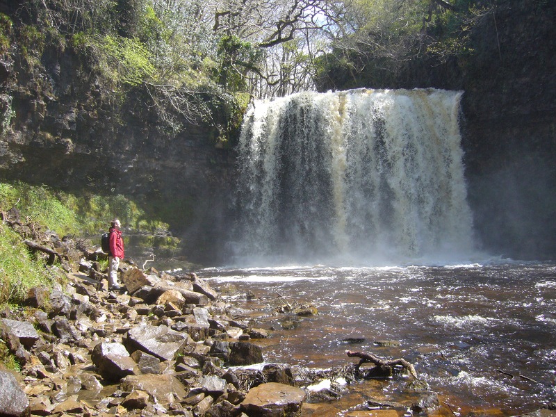
Finally, here's a picture of Sgwd yr Eira:
I will not post the picture of me after I walked
behind it, but let me assure you that I was really
glad that it was a sunny day and thus my clothes
dried rather fast...
|